Beaches
2010
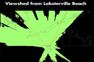
As wind power development looms over the Island, planning agencies and other organizations are beginning to come to terms with what that will mean visually. The Martha’s Vineyard Commission and Vineyard Power have each developed visual simulations to show what Vineyard horizons will look like dotted with wind farms.
And depending on your persuasion, the altered seascapes represent either a pristine panorama blighted by industrial machinery or a stirring reminder of the Island’s potential energy independence.
2008
It’s a whole new, clean green spin on trashy books: on Saturday, August 30, Island author Mathea Levine will sign copies of her new definitely not trashy book I’m Lucy: A Day in the Life of a Young Bonobo at Riley’s Reads in Vineyard Haven — but kids will receive a 20 per cent discount on copies of the book if they bring three or more pieces of beach trash they’ve collected.
1993
The state department of Fishers, Wildlife and Environmental Law Enforcement announced yesterday that it has taken ownership of the Leland beach - 100 acres of virtually unspoiled barrier beach stretching from Wasque to the Dike Bridge on Chappaquiddick.
Purchase price is just under $1 million; the beach, which has been owned by the family of the late Oliver and Edmund Leland since 1907, was purchased through land-taking measures under the state’s eminent domain laws.
1973
Workers have already begun forming new dunes on South Beach’s Left Fork, using dredged sand from Katama Bay and Herring Creek. Both water bodies had filled with sand after December and January’s storms.
Pages
- « most recent
- ‹ more recent
- 1
- 2
- 3
- 4
- 5
- 6
- 7


