2007

Connor Downing

The latest round in a dispute pitting a landowner’s right of access against conservation values played out like a game of cat and mouse in town hall, the courts and the woods of Edgartown last week.

It began a little before 10 a.m. on Friday morning, when Paul Elliott, the president of the Edgartown Meadows Road Association, found workmen cutting down trees along Middle Line Road.

In the weeks ahead, a group of Edgartown residents plans to take a new step to preserve and protect the town's ancient ways and
roads.

As many as 30 volunteers will be sworn in by the town as byway
wardens. Their mission will be to keep an eye out for illegal dumping
and misuse.

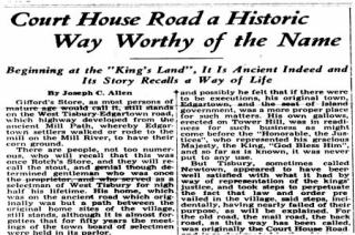
1955

Gifford’s Store, as most persons of mature age would call it, still stands on the West Tisbury-Edgartown road, which highway developed from the ancient Mill Path, whereby Edgartown settlers walked or rode to the mill on the Mill River, to have their corn ground.
 

1929

Not many Vineyarders have heard of the “King’s Highway” or know that any such road exists on the Island. King’s Highway, or “Hie” Way, as it was in the beginning, is, according to tradition, the old road between West Tisbury and Quitsa. It is approximately halfway between the South and Middle Roads and parallels the two from the vicinity of the West Thibury-Chilmark line to a point not far distant from Beetlebung Corner, following the line of Ridge Hill and crossing the Guerin and Henry Allen estates.

Pages