

Climatologists say the prevalence of strong southerly storms that have battered the Vineyard’s south shore this winter are due, in part, to the first El Niño winter in five years. Strengthened by rising and warming waters, Islanders should also expect more of these kinds of storms this season and into the future, according to experts.
Though the Vineyard and the rest of New England typically sees northeasters in the colder months, three storms have come up from the south and pass to the Island’s west, causing severe erosion at several of the Vineyard’s prized beaches.
Regularly-occurring shifts in the Pacific Ocean water temperatures create the phenomenon known as El Niño. During El Niño, warmer waters cause the Pacific jet stream to move further south, changing global weather patterns that trickle down to the Vineyard, said Dr. Peter Neilley, a Chilmark resident and the director of weather forecasting for The Weather Company.

“What we are seeing this winter is pretty much a classic El Niño Winter,” said Mr. Neilley, who oversees the forecasting for The Weather Channel.
The three storms — two last week and one in mid-December — originated from the south, an area of the country that is warmer and full of moisture. Storms with those conditions tend to be more powerful, creating high winds and waves that then take an unimpeded path hundreds of miles to the Island.
Where a northeaster would cross Massachusetts Bay and Cape Cod to get to the Vineyard’s coast, a southerly storm can gain a full head of steam before running smack into the Island.
“It’s a combination that is not good for southern beaches,” Mr. Neilley said. “The path helps them be stronger.”
El Niño happens about every two to seven years. Last year, the National Oceanic and Atmospheric Administration predicted El Niño conditions would be present, likely strengthening winter storms.
Dr. Zachary Zobel, an associate risk director at the Woodwell Climate Research Center in Woods Hole, said that while El Niño plays a part, one of the things he was noticing with the storms was the sheer amount of rain they were dumping on the region during the winter.
According to the National Weather Service, the Island has received about 4.5 inches of rain so far in January, about 2 inches more than normal.
“These storms are coming in and dropping rainfall totals you wouldn’t expect for this time of year,” Mr. Zobel said. “We’re starting to see tropical-like downpours in the middle of cold season.”
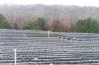
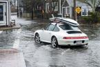
All of that rain, paired with rising sea levels and extreme high tides, exacerbates coastal flooding, and the Island has seen the impacts.
Dunes were flattened, roads started to crumble and sandy beaches turned into rocky landscapes in a matter of hours. On Wednesday Edgartown declared a state of emergency because of the erosion and Dukes County officials feared that Norton Point could not be ready for visitors this summer.

Shelly McComb, a coastal resilience specialist with the Cape Cod Extension and Woods Hole Oceanographic Institution Sea Grant program, said sea level has risen about six inches in the last 40 years.
That extra water gives these powerful storms a better chance of having extreme tides and big waves.
“These changes unfortunately are becoming more normal,” Ms. McComb said. “We’re going to have to adapt and live with it.”
The rapid succession of the storms also roiled the south shore, giving town officials little time to take action before another storm hit. With the ground already saturated, the stormwater also had few places to go, allowing for even more damage.
“It adds up,” Mr. Zobel said. “I almost compare it to boxing, where oftentimes it’s not the first punch or first haymaker, but several body blows followed by a haymaker that makes for a winning strategy, or, in this case, a losing one.”
Going forward, these types of storms may also not be an anomaly. Temperatures across the country are rising – December and January are the fastest warming months – and the air is full of moisture, meaning climate change could juice up what could have once been a weak storm into something more powerful.
“The kind of winter we’ve seen this year, we should expect more of in future winters,” said Mr. Neilley. “The atmosphere is more fueled for these kinds of storms.”
Mr. Neilley did note that erosion and shifting sands on the Vineyard’s south shore have been going on for a long time, and that these issues would always have to be dealt with at some point. Climate change may just be accelerating the timeline and the Island dunes just don’t have time to be restored.
“Having a warmer climate and the rising seas and the stronger storms, the natural beach progression can’t keep up,” he said.
Mr. Neilley also warned that Saturday’s storm might not be the end of the season.
“We should be prepared to get one or two more of these in the coming weeks,” he said. “We still have a long ways to go in winter.”


Comments (1)
Comments
Comment policy »