
From the Oct. 15, 1965 edition of the Vineyard Gazette by Joseph Chase Allen:
Probably the Vineyard is no different from other places in the bestowing of place names, and eventually forgetting them. Place names belong to localities and possess their own individual significance which is appreciated by all who are aware of the background.
When this knowledge is forgotten, the place names are apt to be forgotten as well, and only the older inhabitants of a place experience any real regret.
Members of the present and recent generations are responsible for shifting the designation of Menemsha which is now attached only to the little settlement around Menemsha Creek. Originally it referred to a large area which included Menemsha Pond, the creek, and the village which is now known as Chilmark, or Chilmark Center.
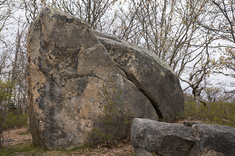
Who knows of Zephaniah’s Hallow? Or the Great Rock, Weskoseems, which stands on the hilltop above it?
In 1700, or thereabouts, the home of Capt. Zephaniah Mayhew stood in this hallow, shielded from storm winds by steep-sided hills on three sides. All is now a part of the Walter A. Edwards property and lies in Chilmark, except for the rock which is on the boundary line between Chilmark and West Tisbury.
To travel to this point, Brownbread Hill lies northerly. It is that elevation looming above the area from which quantities of rock have been mined on the Seven Gates Farm holdings. The hill was so studded with boulders that it was possible to walk considerable distances upon its slopes without stepping upon the ground, and old people gave it the name, holding that it resembled a brownbread loaf, studded with plums.
The principal brook crossing the North Road just west of the gateway to the Ganz estate is so concealed by the bridge that few persons realize it is there. Anciently it was called the Great Brook for it was, in all probability, the broadest stream on the Island. A century ago, Capt. Elijah Howland owned and lived upon a farm that lay along this brook and the name was gradually changed to Howland’s Brook. The Howland farm, and the cellarhole of the house are on the present Ganz estate.
The farm, now a part of the Putnam estate, owned by the late Dr. Charles R. L. Putnam, was owned by generations of the Hammett family, which accounts for another, forgotten place name.
On the Sound shore, nearly a mile from the old farmhouse, there is still to be seen a tiny piece of sandy beach surrounded by huge boulders. These boulders lie on the beach itself and also in the water, but there is a passage through those that lie awash through which a small boat may come and go. This is Jethro’s Landing, so called for the reason that the place was once owned and occupied by one Jethro Tilton.
Down a twisted, rocky cartpath that winds over the ridge of hills to the south, Jethro hauled clay in an ox cart to this landing, and from this beach the double-ended pink of a relative, John Tilton, took the clay to the mainland. For may years the remains of a wooden capstan stood among the low dunes, the only evidence of the use to which this spot was once put. Two stands of heavy oak wood lie to the west. Both have place names, if anyone remembers. Bordering on North Road is Cooper’s Woods, though why so named, no one knows. The accepted tradition is that trees for cask-staves, or possibly hoops or both, were once chopped there. The other, far to the north and invisible from the highway, is Beck’s Woods, with Beck’s Pond lying nearby a few rods from the beach. On this land, the boundaries of which cannot be found today, lived Rebecca Skiffe at the time of the Revolutionary War. Whether she was married or single, no one knows, but she must have been a character if one may judge from the shortening of her name to Beck. That she was some relative of James Skiffe, the pioneer, is certain, but whether blood kin or by marriage is not known.
The Middle Road climbs a hill and drops into a hollow opposite the home of Mrs. Ellsworth West. Adjoining this property, on the west, is a small but fairly level field, which has figured importantly in early Island history, especially up-Island history.
This field was once known as the Hewing Field, where logs were brought to be hewn into building timber by the proprietor, whose name, aptly enough, was Ewing. It is not likely that a dozen persons living today ever heard this field so-called or know the facts about it.
The Dr. Fisher Road can be located in spots as it crosses the Great Plain. The first was connected with the Chilmark Brickyard, the second was the route by which the four-horse teams of Dr. Fisher hauled flour from his mill to his hardtack factory in Edgartown. The names are virtually unknown.
It is thus that place names come into being, are well known for a time, and then forgotten. The industries associated with some have long since been abandoned, and wilderness has reclaimed most of such places, concealing them from all eyes.
Compiled by Hilary Wall
library@mvgazette.com


Comments
Comment policy »